Hailing from an island nation, I think of borders as simple – the country ends where the sea begins. On the European mainland, however, the tale can be infinitely more complex. Having been fascinated previously by the tripoint of Belgium, Germany and the Netherlands, I spent some of this trip exploring another Dutch/Belgian cartographic curiosity: the towns of Baarle Nassau and Baarle Hertog.
To explain what’s going on, I feel like I have to reach not for geography, but geometry. So, at the risk of falling into old maths lecturer habits, some definitions are needed. First up are exclaves: parts of a country entirely cut off from their motherland by the territory of foreign nations. Simple disconnection isn’t enough: an island isn’t an exclave, and nor is, for example, Alaska. But if the only way to get to a particular place is overland, and none of that land is yours, then you have an exclave. An enclave is the special – but most easily visualised – case of an exclave wholly within a single country.
Just visiting an exclave would already be a novelty for me, but the two Baarles offered much more: not just one enclave, but thirty! Baarle Nassau is the Dutch part, and would be an unremarkable town of about 7,000 people in North Brabant (confusingly, a province in the south of the Netherlands) were it not for the intrusion of its neighbour. The 22 enclaves of Belgium that make up Baarle Hertog only cover about 10% of the area, but add another 3,000 people to the joint community. There is a single Dutch enclave nearby in the Belgian province of Antwerp, but there are also seven counter-enclaves: Dutch territory encircled by Belgian, itself contained in the Netherlands! Such an arrangement is almost unique in the world – the only example outside of Baarle is a counter-enclave of the UAE in an enclave of Oman.
There is seemingly no rhyme or reason to the arrangement of the enclaves, which first arose in medieval times but continued to change shape and number throughout the centuries. This map captures the current borders – which were only finalised in 1995! – and also shows how by walking along a single road for less than thirty minutes I was able to switch countries eight times:

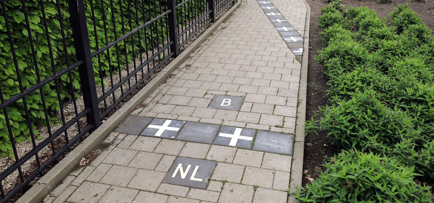
Although on paper some of the smaller enclaves may look like sensible shapes, in person the border cuts through homes and businesses seemingly without care for property boundaries or street grids. To help keep track (at least for tourists like myself), lampposts and house numbers are marked with the flag of the country they’re in, whilst the border is often paved into footpaths or roads. It is often said that the map is not the territory, but perhaps here the territory is the map!
To avoid the absurdity of homes where the sofa might be in one country, but the TV another, the convention arose that an entire property is deemed to be in whichever nation its front door stands within. Oddities nonetheless occur: in a residential area to the north I saw houses which were Belgian, but connected only to Dutch streets; another plot is almost entirely in the Netherlands, save for 2 square metres of the garden (a Belgian tax bill would occasionally arrive, for less than the stamp used to send it). A liquor store, De Biergrens, partly takes its name from the border running through the middle of the sales floor, and maintains an address in both; as does a house whose door is bisected by a boundary line.

Still, this approach proved convenient for one 84 year old resident. Having long considered herself to be living in Belgium, the program of measurements leading to the definitive 1995 borders instead placed her just on the Dutch side of the street. Fortunately, by swapping the positions of the door and a window, both she and the house were able to migrate back into the neighbouring enclave.

Notice also that the street number depends on the country – its Dutch neighbour is number 1!
With the Netherlands and Belgium being founder members of the Schengen zone, this complex geography can today largely be ignored. Moreover, Dutch-speaking residents of Baarle Hertog probably have more in common with their neighbours in Baarle Nassau than their francophone compatriots in the west of Belgium. The only cultural fault-lines I could find were culinary: at a cafe I could get my Frites topped with mayo prepared to either Dutch (sweet) or Belgian (sour) tastes; whilst a bakery offered a choice between Hollandse or Belgische sausage rolls.
But at times the distinction was of great importance. In the First World War Belgium was occupied by Germany, whereas the Netherlands maintained neutral status. Surrounded – and hence shielded – by Dutch territory, Baarle Hertog became a site of resistance activity, with a transmitting and receiving station being set up to intercept German communications and relay them to Belgian forces in France. This took six months to construct, with the people of Baarle Nassau managing to look the other way whenever building supplies were brought in. German messages of mutiny and requests for ceasefire negotiations were picked up here, hastening the end of the war.

Fast forward a century, and the COVID pandemic once again made the crazy borders more than just lines on the ground. I got talking to an old guy who described the situation then as a nightmare, although he at least was fortunate enough to live in Baarle Nassau. In Baarle Hertog residents were subject to the harsher Belgian lockdowns – spare a thought for the 45% of them who are Dutch, but could only watch their neighbouring countrymen live less restricted lives!

On my border-hopping stroll along the Visweg I learnt of one last geographic quirk. This again sounded more like a thought experiment in abstract geometry than something that could arise in reality: if two shapes meet at a single point, are they one region or two? In a field to the east, two parts of Belgium do precisely that. Since you can’t get from one to the other without also passing through the Netherlands, they are argued to be distinct enclaves. Moreover, their intersection is considered a quadripoint: although it marks the meeting not of four countries, but of four international borders.
A strange daytrip, perhaps, but one which offered plenty of interest – as well as adding my first new MTP region of the year, and a Nomadmania M@P entry. With unusual border features often residing in the middle of rivers or on the peaks of mountains, being able to take a bus to Baarle from Breda was entirely straightforward. Once I’d arrived, it was clear that like-minded visitors regularly pass through: the larger enclaves all have information boards (in Dutch and English) describing what makes them special. I’ve stolen some of their anecdotes above, but there’s plenty more to discover if you’re ever in the area!