I have a long-running fascination with borders: an intersection of politics and geography, when viewed (as I am prone to do) from a mathematical perspective they often seem improbable things, with all kinds of, well, edge cases. During the pandemic I dreamt up various country-crossing itineraries, and last year I made a start on them by ticking off the counter-enclaves of Baarle Nassau / Hertog. However, this year’s trip has far older roots – way back in 2018 I visited the Dutch / German / Belgian Drielandenpunt, my first tripoint. In that writeup I mentioned my interest in touring the three such points where Luxembourg meets its neighbours; fast forward five years, and I finally did so!
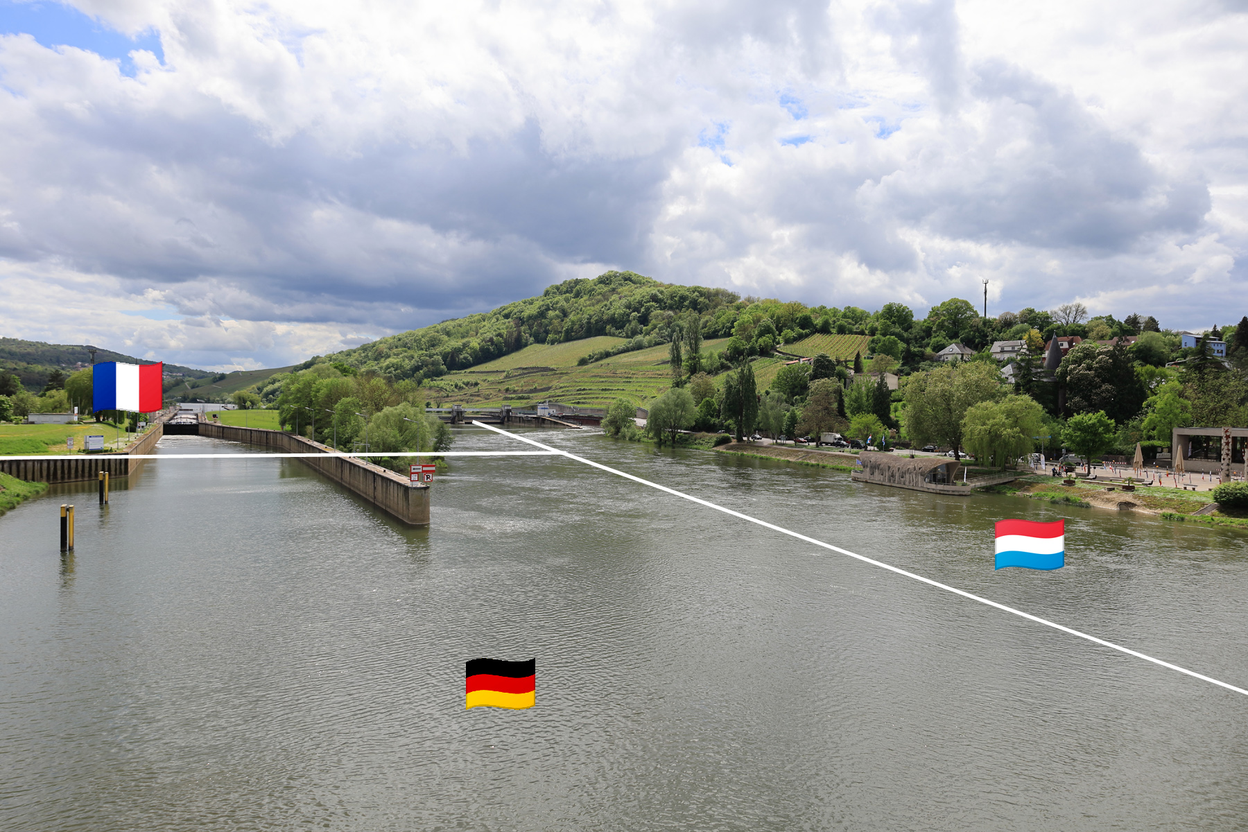
Germany / France / Luxembourg
Having never visited Luxembourg before, I couldn’t resist the idea of arriving via one of the tripoints. Of the three, Schengen seemed the most practical, although I hadn’t factored in the hazards of a long ride on Deutsche Bahn. Starting from Frankfurt, the trip was always going to take several hours, but I had imagined comfortable trains and a leisurely break of journey midway. Delays ruined my planned itinerary before I’d even got moving, a missed connection in Koblenz relegating me to much slower regional trains and reducing my lunch hour in Trier to a six minute transfer.
Pushing through, it took me five hours to reach the end of the line: the derelict station of Perl. All three Luxembourgian tripoints are located in rivers, so I wouldn’t be able to repeat my Drielandenpunt dash around any of them. Here I neglected to enter France at all – although I did later fly my drone into it – instead crossing the Moselle (by bridge, the Alte Moselbrücke) to claim my 23rd UN country.
The Schengen agreement that allowed me to roam so casually across borders all weekend is named for – and was signed in – this town, and the riverside has numerous celebrations of the European project. The chronology of “ever closer union” is set out through photos of the signing of key accords, from the Schuman Declaration in 1950 to the Lisbon Treaty of 2007. The flags of the EU states are all on display, alongside a sculpture adorned with stars which, on closer inspection, depict iconic locations from each country. A nearby monument, Unitatis, symbolises European unity through two giant interlocking hands; although I felt the argument was better made by fragments of the Berlin wall, a stark reminder of the alternative.
A buoy in the river marks the tripoint; a curious brutalist barge is half gift shop, half cycle hire; across the road, a small – and free – museum houses the actual Schengen agreement along with a wealth of information panels. (A display of the key facts about each EU member has been tragically updated with a sticker over the UK panel simply stating “Brexit 31.01.2020”). On my way to the bus stop I found one more monument by chance, but it’s a crucial one, marking the signing of the Schengen agreements aboard the Princess Marie-Astrid, which was moored at the quay.
A bus ride to the capital – free, like all public transport in the country – takes around half an hour; if you’re interested in visiting Schengen, I’d strongly advise flying in to Luxembourg then making an excursion, rather than routing through Germany as I did! However, practical journeys were not exactly the theme of this trip, and I am glad I was able to add “entered a new country on foot” to my travel achievements…


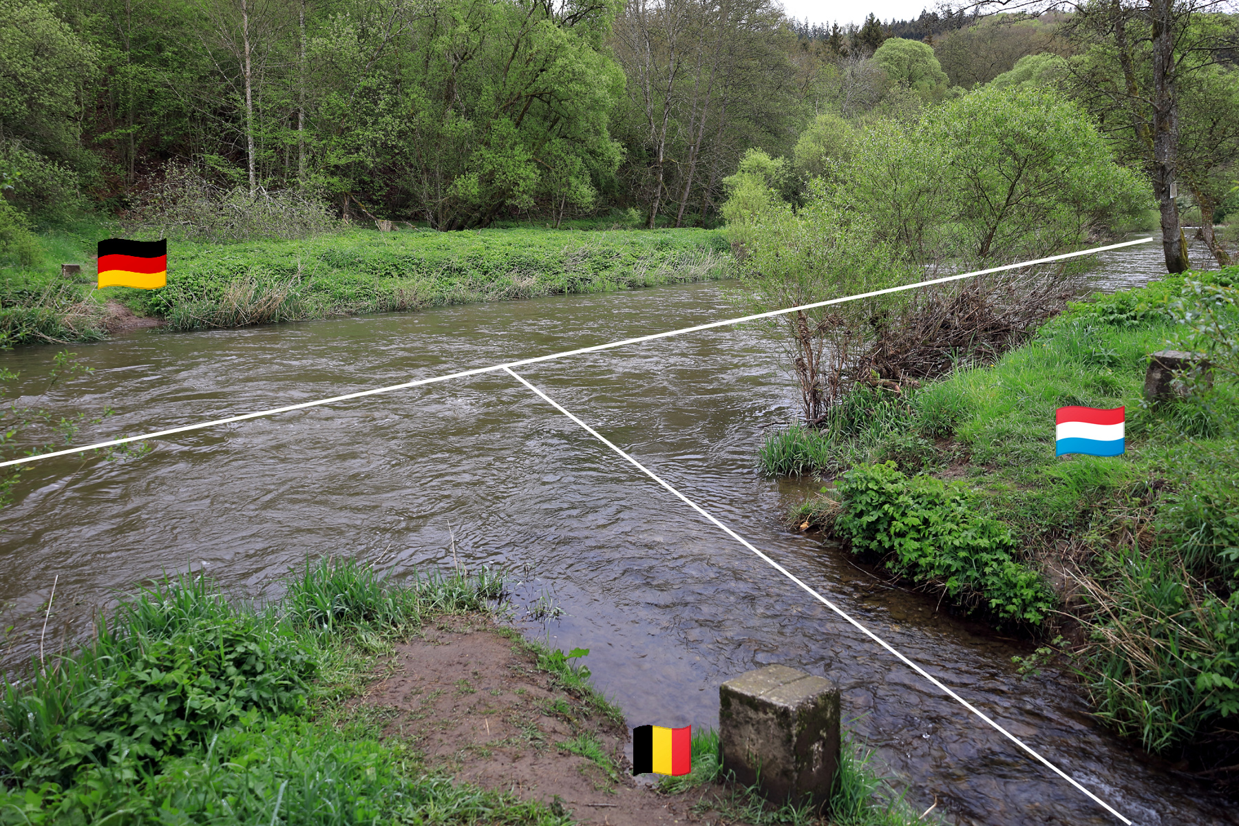
Luxembourg / Germany / Belgium
My next target was less than fifty miles north of Luxembourg city, but this once again proved a lengthy journey by public transport, taking nearly four hours to reach the border triangle at Ouren. Admittedly, I had poor luck: normally you can take a train all the way to Clervaux, but this weekend the line was closed for engineering works and rather than endure a rail-replacement service I tried to make my own way from Ettelbruck, the furthest station I could reach.
I reached Heinerscheid by bus without difficulty, where I had hoped to pick up lunch. I seemed unwelcome at the only restaurant, and the only café was closed; establishing these facts took just long enough to miss the hourly bus out. Thus I may have inadvertently become this village’s most dedicated tourist, roaming its few streets for 45 minutes in search of anything interesting before rain drove me to shelter.
The even smaller village of Lieler is as close as you can get by public transport, leaving a mile and half trek to the tripoint (which is why I didn’t simply walk the 3 miles from Heinerscheid). Google describes the route as ‘mostly flat’, but I had been caught out by this before in Hakone, and I once again found myself presented with a plunge into a valley. I was a bit concerned by the lack of pavement, but traffic was light; wet weather turned out to be a bigger problem.
I knew I was close to the tripoint when I began to encounter abstract art: “Perception of Limits – Limits of Perception” being the first item on a sculpture trail that runs for several miles along the Our into Belgium. I didn’t have time to pursue that, but I did explore the Europe Monument: four large stones symbolise the countries of the Eifel and Ardennes region, whilst a fifth celebrates the founding of the European Community. These were arranged within a park that is split -as are Luxembourg and Belgium – by the Ribbach river; following this to the Our, I thus arrived at the Dreiländereck.
A convenient bridge allowed me to return briefly to Germany, and served as a launch site for my drone. Small markers indicate which country each bank belongs to, and there is an information board in the Belgian sector. But otherwise the tripoint goes largely unremarked: the main source of interest in the area seems to be a series of cycling routes, which were in heavy use during my visit. But in a way, that lack of fanfare is an embodiment of the ideals espoused at Schengen. As another sign described, the time of toll keepers and gates is long gone; now the border is a connection, not a barrier.


")
")
Belgium / Luxembourg / France
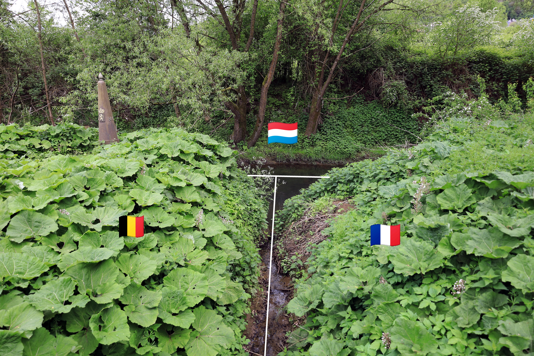
I have chosen some niche destinations over the years, but this last tripoint is definitely one of the hardest to explain burning a day of leave on. From my research I wasn’t even sure I would be able to access this seemingly neglected patch of land wedged between railway tracks, waterways and busy roads. Nor did I expect to find much if I succeeded.
The closest I could get by train was Rodange, a half hour ride from Luxembourg’s main station. For once my lunch plans worked out, so after fuelling up on duck masala at Restaurant Pokhara I completed the final mile on foot. Almost all of this was a straight shot along Rte de Longwy, a largely residential street. However, to clear a railway line I had to join – and then cross – a national road in no way intended for pedestrians. Fortunately traffic was light on a Sunday, and after hopping the crash barrier and making a run for it, I was able to survey my afternoon’s entertainment.
Remnants of a paved track lead down into a meadow, vehicle access blocked by heavy concrete blocks. This lead to the Chiers river, which emerged from two corrugated metal tunnels running beneath the road. Steam billowed from a chemical plant; Brambles reached to knee-height. Not the most probable holiday spot!
Amazingly, I was not the only visitor – a car was parked at the top of the track, its owners making their way back across the field. (Checking Google maps later, I was amused to see the area was tagged as “busier than usual”). Thanks to them I was able to locate the only clue of the tripoint’s existence: one of the Gossemaarke posts which indicate the Belgian-Luxembourgian borders. Manoeuvring my way through trees to the river I was able to spy its counterpart across the water; uniquely, this pair share a number.
To explore further I would have to cross the river, and having watched too many parkour videos recently I did this across the top of the tunnel mouths rather than returning to the road and finding a new descent point. I did not linger in Belgium, instead finally setting foot in France via a bridge crossing a narrow stream – more of a ditch – which defines the tripoint by meeting the Chiers.
The French section was the only one that could be described as developed for visitors, although still a work in progress: a shelter for an information board was bereft of any information. But there were wooden fences along paved cycle lanes, plus a picnic area by a meadow (every table sadly already graffitied with crude swastikas and neo-Nazi numerology). I doubt this location will ever become a tourist destination, but it could make a pleasant rest spot for, say, a multi-country bike ride.


")


")


For me, though, my time here was the conclusion of a project long in the making. ‘Checklist travel’ is often criticised as being superficial, but I think tracking down these geographic curiosities lead me to see far more of Luxembourg than I otherwise would on a weekend break. I have a few more improbable itineraries in mind; hopefully it won’t take me another five years to make them a reality…
If you would like to see more photos from this trip, or follow it on a map, I also logged it using polarsteps.